Back مقاطعة ريتشلاند (إلينوي) Arabic Richland County, Illinois BAR Ричлънд (окръг, Илинойс) Bulgarian রিচল্যান্ড কাউন্টি, ইলিনয়স BPY Richland Gông (Illinois) CDO Ричленд (гуо, Иллинойс) CE Richland County (kondado sa Tinipong Bansa, Illinois) CEB Richland County, Illinois Welsh Richland County (Illinois) German Condado de Richland (Illinois) Spanish
Richland County | |
|---|---|
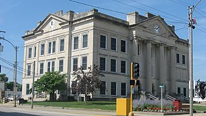
 Richland County Courthouse in Olney | |
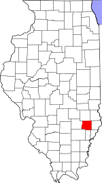
 Location within the U.S. state of Illinois | |
 Illinois's location within the U.S. | |
| Coordinates: 38°43′N 88°05′W / 38.71°N 88.09°W | |
| Country | |
| State | |
| Founded | February 24, 1841 |
| Named for | Richland County, Ohio |
| Seat | Olney |
| Largest city | Olney |
| Area | |
| • Total | 362 sq mi (940 km2) |
| • Land | 356 sq mi (920 km2) |
| • Water | 1.9 sq mi (5 km2) 0.5% |
| Population (2020) | |
| • Total | 15,813 |
| • Estimate (2021) | 15,796 |
| • Density | 44/sq mi (17/km2) |
| Time zone | UTC−6 (Central) |
| • Summer (DST) | UTC−5 (CDT) |
| Congressional district | 12th |
Richland County is a county located in the U.S. state of Illinois. According to the 2020 United States census, it had a population of 15,813.[1] Its county seat is Olney.[2][3]: County Seats
- ^ "QuickFacts". United States Census Bureau. Retrieved January 23, 2023.
- ^ "Find a County". National Association of Counties. Archived from the original on May 31, 2011. Retrieved June 7, 2011.
- ^ "Richland County". Illinois Regional Archives Depository (IRAD) System. Office of the Illinois Secretary of State. Retrieved January 22, 2023.